Sunday, August 24, 2014

Day 2 on the Cassair

Next day we drove the Telegraph Road to the town of Telegraph Creek.  It’s located on the Stikine River and was a major supply point during the Gold Rush.  Now it is mostly abandoned, although a few Tahltan Native people still live in the area.


One of the fishing villages at the junction of Telegraph Creek and Stikine River

This is Main Street.


And this is the only business we found open in the entire lower town.

There is another section on a hill where most of the 300 town residents live.  Located there is a gas station/grocery store, health center, school and community center.


The Cassiar Highway

Day 1  Watson Lake to Dease Lake

Leaving Watson Lake, it is 13 miles West to the Junction with the Cassair Highway.  The road is 2 lane with little to no shoulders and no center line.  For the short distance that is in Yukon Territory there are lots of potholes and frost heaves, then upon entering British Columbia, the road gets better.  There are still frost heaves and potholes, but not as many and most have been repaired so the road is smoother.  Another plus for the highway is NO traffic!

Our first stop was at Jade City.  This is not really a city, but a wide spot where the Jade that is mined in the area is cut and sold. At least some of it.  A lot is sent to the Orient for cutting and polishing, then sent back for sale.

Then the road winds down to Dease Lake where we spent the night.

Tuesday, August 19, 2014

Teslin to Watson Lake

Tried to get the oil changed in the truck at WM early this am but the tech didn’t show up for work so we headed out.  This is a repeat road for us since we came in on the same route.  Even stayed at the same campground – Teslin Lake Campground, a Yukon Territory Park – overlooking the lake.  This time we visited the George Johnston Museum.  The raspberries growing in front of the museum were delightful!  Since the day was sunny, we sat outside for a while.  The rain began in the late afternoon, continued thru the night.  The next day was more rain.  We headed out with caution, both of us watching the road.  At the first potty stop, we found 1/4 inch of water inside!  After cleaning it up, we continued on to Watson Lake.  Spent the balance of the day cleaning the rig.  Soon discovered where the water was coming in from.  When the tire came apart, it smacked into the fender well bending it up, leaving a huge opening for water to come in.  At the suggestion of the campground owner, Jon got out the scissors jack in an effort the get the cover back down where it belongs.  It worked, mostly, still had a gap.  Jon came up with the idea of making a “bandage” with coke cans, he cut them apart making long strips.  Using super glue to hold them in place.  Now we need silicone and duct tape to complete the job.  Only problem is that all the stores are closed because of Discovery Day and won’t be open again until Tuesday. 

We drove out to the Airport, it’s a historical site now, but during WWII it was one of the ferry points on the lend lease program.  Lots of great historical photos in the terminal building now.

Tuesday we got the supplies we needed and completed the repairs as best we could.  Our friends Kim and Jim arrived this afternoon, we’ll travel together, sort of, to Hyder.

We’ve had rain sporadically every day here.  Hope it’s done now.

Haines to Whitehorse

Left Haines in the rain, well mist actually.  At the top of the pass fog  for several miles. 

Then clear sunny skies. Stopped at Million Dollar Falls.

And this wonderful old bridge, not used anymore but still intact.

Took a side trip to see the Village of Champagne.  We don’t think anyone lives here now.


It was a mostly uneventful drive until we were about 30 miles from Whitehorse.  That’s when a tire on the trailer lost tread.  About an hour later we were back on the road with help from some Alberta fellows, Thanks guys!  Since both campgrounds are well out of town, we decided to camp at Wal Mart, needed some provisions anyway.  Next morning we went looking for a tire.  Well this Wal Mart does not carry trailer tires so over to Canadian Tire, not there either.  The Goodyear dealer didn’t have any in stock so he sent us to Integra Tire.  They had what we needed for a very reasonable price.  Left the tire and got provisions.  After lunch we took the trailer over to Integra and they changed out the tires for us. 

Back to WM, then off to the Wild Animal Preserve out Takini Road. Saw some Caribou, Mule Deer, Bison, Muskox, Snowshoe Hares, Elk, Bighorn Sheep, Mountain Goats and Thinhorn sheep.  Also lots of bear popsicles ( AKA Arctic Ground Squirrels, these little critters are true hibernators).  Didn’t see the Lynx or the Arctic Fox. 

Then we went in search of the Mining and rail museum.  Took a wrong turn and ended up at the Marsh flats where we saw Eagles.

That’s all for now!

Thursday, August 14, 2014

More Haines

Yesterday dawned with rain but cleared up around mid afternoon and even got sunny by dinner time.  This morning it was raining again!  Rain is expected in this area for the next week!  So we have decided to move on towards Watson Lake then down to Hyder.

A cruise ship arrived here yesterday so the town was a buzzing and crowded.  Here’s a few parting shots.

There are two state parks in Haines, one is Chilkoot State Park and the other is Chilkat State park.  One is North of town and the other is out Mud Bay road to the end South of town.  The shot above is from the park South of town.  Under the clouds is a glacier.  This park didn’t look used at all.

Dalton City, where the movie White Fang was filmed., is part of the fairgrounds.

This lovely seaside cabin is the one that Jon wants.

On the hillside behind the cruise ship is Fort Seward.  Click on the photo for a closer look.

That’s all until we get to Hyder.

Wednesday, August 13, 2014

Haines

We arrived in Haines Tuesday afternoon, got set up at the Hitch Up RV Park (nice sites on the grass) and went exploring.  First in town to Old Ft Seward, a former military Fort.  Some of the buildings are now shops (one is a local artist doing totem carving), the old officer quarters are now private homes and what was the commissary is now a hotel.  Other buildings have been restored and have plans for use too.  I’ll try to get some photos later today.

Then we headed out Lutak road ; past the ferry dock the roads winds along the bay and ends at the State Park on Chilkoot Lake.  Just before you get to the lake there is a fish weir and that’s where we saw a sow!

According to the ranger, her route is from the fish weir, along the river to the beach then up along the forest side and maybe back again to the fish weir.  We saw her swim across the river then again on the beach.

Also spotted several eagles and the nest with one chick.  The next was near the top of a spruce on the other side of the river.  This one was fishing near the bank.

It’s raining as I write this so we will probably do some indoor stuff today.

Friday, August 8, 2014

McCarthy Road

Packed a picnic lunch and headed out for a day of exploring.  Beautiful sunshine with a few puffy clouds.  The road follows the old Copper River & North Western Rail road bed, or as it was nicknamed “Can’t run and never will”, all the way to Kennecott.  The mine closed in 1938 but not before taking over $300 million in copper to Cordova by rail and from there by boat to Tacoma, Washington to be processed. 

Here’s one of many trestle bridges that needed to be built.  

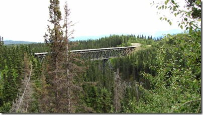
And this one is no longer used, gee, wonder why?!

Pretty good gravel road almost all the way, at least where the road work is going on, lots of potholes and frost heaves on the rest of the road.

After 60 miles, and 2 1/2 hours, we arrived at the end of the road.  Picnic lunch and a walk over the bridge (over the Kennecott River) to the shuttle stop for a short ride into McCarthy and a longer (6 miles) ride to the old mine.

The tall building, 14 levels and the tallest wooden building in America, is the Stamp Mill.  At the base of it is where the ore was bagged and across from it is the Machine shop and power house, can you see the smoke stacks?  In the foreground is the leaching plant and the small building on the right side of the picture is the General Manager’s Office.

Enough power was generated here to power the entire town and 4 mines.  There was also a phone system through out town and steam heat in all the buildings.


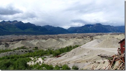
That is not tailings, it’s the dirt on top of the glacier.  Below is the Hospital and the East Bunkhouse separated by National Creek.


Another view of the mill 


After walking around for 3 hours we boarded the shuttle for the ride down the hill to McCarthy.  The hotel is in beautiful shape!  Cross the street for the bar.

That’s Root Glacier.

One last look back. 


We got back to the campsite at 7:45pm and see that our friends Ed and Sandy & Steve and Nancy have arrived.  They’ll do the trip tomorrow.  We will head back to Glenallen and maybe on toward Tok.